City ≠ city
City ≠ city. Place ≠ place.
You know when you’re two thousand miles from home and somebody asks where you’re from and you just name the nearby major city even though you actually live in an adjacent suburb, because who the hell would know where that suburb is? I wish we’d think of cities that way for real, not just occasionally out of convenience.
Let’s divorce the geographical notions of “city” and “place” from the legal definitions. I’m tired of people being so hung up on municipal boundaries when they think of their cities. Tired of imaginary lines on maps, having little or nothing to do with patterns of intraurban human settlement, separating “here” from “there.” Tired of people in my city thinking it functions in isolation from the larger city next door, and of people in that city thinking my city is just some other place, hardly different from a town 80 miles away. In your typical American urban area, instead of a great, proud city I see a bunch of heres and a bunch of theres, each one thinking it’s better than the others. Look at it from afar, or even from a hot air balloon. It’s one centralized urban place. One city. In my hippie dream America we’d know where the lines on the map are (let’s face it, they are of civic consequence) but wouldn’t live by them.
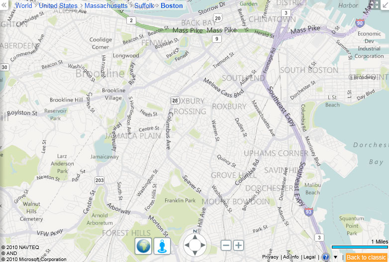
Interesting, then, is that these lines aren’t found in many of the maps we all frequently use now. Google Maps will show city names but not their extents. The new Stamen design of Bing Maps is even more wonderfully ambiguous. Here’s the map I see upon entry, showing where it thinks I am.

I see four levels of place labels, and not all of them correspond to municipal entities. One of the labels is even a place that contains parts of three different cities in three different counties. Most notable, though, is the large, semi-transparent “Boston” label, and I really like the overall impression it gives of the city. I live in Cambridge, which is labeled on the map and clearly is a real place, but its precise definition is unknown, and by the labels it seems to be a part of this greater city called Boston. And that’s just how one should think of the city from this distance.

Zoom in a couple of steps and you get a view that is almost officially ambiguous—the ghosted labels name neighborhoods that in my experience don’t have boundaries that any two people would agree upon. (Other cities have more certain neighborhood boundaries, but real neighborhoods are still hard to pin down.) Again the labels do more than allow for display of a hierarchy; they nicely depict the reality of fuzzy, uncertain extents of urban places. In a way, this map is more accurate than one with precise lines. (Bing does show county boundaries, though. Counties are stupid too.)
So here’s to Bing and others reshaping our urban geographical notions. Even if the vagueness is annoying when we wear our Practicing Cartographer hats and are looking for good reference maps.
On a closing note, an excellent attempt to move beyond political boundaries as geographical definitions is the CommonCensus project, which aims to map the spheres of influence of American cities (also sports teams). Have a look at the maps, and please do contribute your response to the survey questions!
Tagged bing, cities, labels, rants, urban geography


11 Comments